[Leicester North]
[Abbey Lane Area]
[North Viaduct]
[Leicester Central]
[Braunstone Gate]
[Goods Yard]
[Aylestone]
[Bridging the Gap]
[Notes for Visitors]
[Old Photographs]
[Archive]
[Links]
This section covers Leicester Central Station.
Although nearly everything at platform level has long gone there is still much that remains of Leicester Central Station, making it one of the most rewarding areas to explore.
Click here for a map of this area from Bing
Notes on using the Bing Map
The map
linked to is the Ordnance Survey map.
To see an aerial photograph of the area covered by the map click on the tab labelled “Ordnance Survey” near top right of the screen and select ‘Aerial’ from the
drop-down list.
When finished with the map click on the browser ‘Back’ button till you return here.

Leicester Central station on Great Central Street in January 2020, after the structure had been refurbished, before the new interior has been fitted out.
Update June 2019 - The Leicester Mercury announced that the remaining station buildings are to house a bowling alley run by the company ‘Lane 7’.
Update September 2019 - In an update the Leicester Mercury reported that the bowling alley will be part of an “entertainment
‘village’ featuring differing food and drink offerings, as well as tenpin bowling and other gaming attractions”. Due to the considerable work required this is not due to open until 2020.
Update Saturday October 24th. 2020 - The ‘Lane 7’ ten-pin bowling alley, games area, and eating area opened.

This is how Leicester Central Station looked for several decades before the start of redevelopment, which commenced in early 2018. The port cochère was latterly split into two and each part was used by a vehicle repair company. This is the ‘before’ photograph, compare it with the ‘after’ photograph, above.

The central entrance showing the new ‘LEICESTER CENTRAL’ sign and the new glazed top line, January 2020.

Leicester Central station after refurbishment of the structure, thankfully including the distinctive entrance to the parcels offices on the left. The roadway in front has been pedestrianised after the tram tracks were dug up.

For comparison, here is a coloured postcard, posted in 1910, showing the original ornate frontage of Leicester Central station with an electric tram passing. This ornate frontage was greatly simplified, apparently in the 1950s, as shown in the previous photograph above.

Inside the refurbished porte cochère, seen during a supervised tour round in January 2020 before being fitted out with the planned bowling alley. The metalwork of the roof has been refurbished, and new glazing bars have been fitted together with new glass.

As a comparison to the photograph above, this is the port cochère as it looked in 1967, when the Rugby-Nottingham shuttle service was running. The booking hall and tunnels to the platforms were through the entrance on the left.

In January 2020 during the refurbishment, these are the serving windows in the booking hall.

For comparison with the photograph above, this is a similar view in the booking hall in 1967. The windows were not in use by this time since the only service running was the Nottingham - Rugby shuttle service where tickets were purchased from the guard.

In January 2020 during the refurbishment these are the, now blocked up, three passageways under the trackbed which led to stairs to the platforms.

Again for comparison these are the three passageways under the platforms in 1967, and at this time only the one on the left was still in use and led to the south
staircase.
An old photograph from the 1930s shows these with signs, left to right, “TO THE TRAINS - PASSENGERS”, “TO THE LIFT - LUGGAGE ONLY”, and “FROM THE TRAINS - PASSENGERS”.

Update August 2020 - Seen through a window, the mezzanine floor has been installed and fitting out for the bowling alley and bar is underway.
Update Saturday October 24th. 2020 - The ‘Lane 7’ ten-pin bowling alley, games area, and eating area opened.

Another view through a window during fitting out. Yes, that is an old Bedford ice-cream van on the mezzanine floor and is sure to be an interesting talking point.

Some of the ten-pin bowling lanes, seen through a window from Great Central Road.

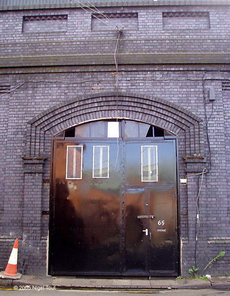
At track level, standing where the Up Main Line ran, looking north. The Parcels Office on the right, which is also being redeveloped, had a siding with a small dock running alongside - the white van is parked across the sites of both of them.

At track level, looking back from as far as you could easily go (a company had fenced off the whole of the northern end). This is looking south, towards London, with the Parcels Office on the left. After a bad fire affected a couple of the near units on the right, those units were demolished, see photograph below.

Update September 2024 - There was a bad fire early in the morning of May 2nd 2024 in a couple of the warehouse units in use by a ‘Cash & Carry’ business. Several of the units were subsequently demolished, as can be seen in this photograph taken through the protective fencing which was put up. This was taken looking north from a position level with the end of the blue-brick wall seen on the left in the previous photograph.

Update September 2024 -
This area shown in this photograph could no longer be reached due to being fenced off after the bad fire and demolition of some of the industrial units.
A little further along, All Saints Road runs under the track bed which is supported by a bridge.
The bridge is still in place (see below) and no buildings have been erected on it. This shows part of the bridge with a section of the down-side, north bay platform still in place, complete with edging stones and paving slabs. There is a similar section of the up-side, north bay platform behind the photographer.
A look around the outside of Leicester Central Station

Update March 2026: The vehicle repair workshops which were built to the north of the Central Station frontage, now the ‘Lane 7’ ten-pin bowling alley, along Great Central Street have been demolished.

Panoramic view of the demolished workshops, both sides of All Saints Road which goes off to the left at the traffic light and under the grey steel bridge. The GCR viaduct where the station platforms and buildings were can be seen behind. The Leicester Mercury reported that there are plans to build a cinema and micro-brewery on these two sites, https://www.bbc.co.uk/news/articles/clyz50l5q5lo.

Panoramic view of the north part of the site to be redeveloped, with All Saints Road on the left which goes under the site of the old station platforms. This bridge is still in place to give access over the road to the northerly industrial units on the site of the platforms. The roofs of the units can be seen on the viaduct. The Leicester "Bring The Paint" festivals have resulted in many walls in this area, including under this bridge, being covered in garish graffiti.

Looking west down Soar Lane with the end of the GCR station viaduct, faced with a new wall, on the left. There was another very deep steel bridge across here, as shown in the Old Photographs - Leicester Demolition 1 section.

Update June 2022 - As mentioned, above in May 2022 the Leicester "Bring The Paint" festival was held and many walls in this area were covered in garish graffiti including the previously attractive wall here.

This photograph was taken after walking round the north end of the station to the rear, and looking back along Soar Lane. Graffiti has also been applied to the side of the station viaduct along Jarvis Street.

Turning and looking to the right shows the rear of the station backing onto Jarvis Street and the industrial units built on the site of the platforms. Much graffiti has appeared on the walls here during the festival.

Railway-based graffiti—is it more acceptable?

Looking south along Jarvis Street at the rear of the station. There is great industry here in the arches of the viaduct with many car repair and re-spray businesses working away underneath the industrial units on top!
Over the years, as part of the “Waterside Development” regeneration of the area there have been proposals that “The railway arches could become workshops, artisan units, cafes and bars”. This could still happen.

Looking further south along Jarvis Street with the rear of the bridge over All Saints Road.

In 2017 demolition of the area between the Great Central viaduct and the river Soar as part of the “Waterside Development” provided a panoramic view of the
viaduct. This view has now been lost through the completion of a new building in the foreground..
To left of centre is the ex-GCR power house.

The ex-GCR hydraulic power house survives across the road from the station, on the corner of Jarvis Street and Alexander Street. It is an isolated old building next
to new student accommodation on the left while the station viaduct is on the right.
Presumably, there had been a hydraulic accumulator in the tower which provided power to the original hydraulic goods lift in the station across
the road.

The regular pattern of the arches of the viaduct is broken opposite the old hydraulic power house building where there was a rear entrance, largely for goods, at the large black door. To the right are some rooms complete with the chimney built into the viaduct wall.
This was a rear entrance to the station and opened onto a wide passage which gave access to the lift to the platform, which was also reached from the front of the station
by one of the three narrow passages shown in the old photographs of Leicester Central. The entrance is positioned on Jarvis Street, opposite Alexander Street. It
is wide enough to accommodate small carts and could have been used to transport items to and from the platforms (e.g. perhaps beer barrels for the buffet) avoiding the passenger areas at the front of the station.
It is not known
if it was used as an entrance by any travellers, such as workmen in nearby factories.

At the south end of the viaduct, just beyond the last of the full size arches, is the entrance to the chamber which was built over a Roman mosaic floor. In 1977 the mosaic was moved to the Jewry Wall Museum a couple of hundred yards away.
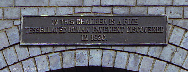
The cast iron sign that used to be above the entrance describing the chamber — “In this chamber is a fine tessellated Roman pavement discovered in 1830”.

This is the magnificent Blackfriars Roman Pavement, now preserved only a few hundred yards away in the Jewry Wall Museum in Leicester, which unfortunately is closed for
rearrangement.
The Railway Archive site shows this mosaic in its original position under the viaduct at https://www.railwayarchive.org.uk/getobject?rnum=L3116 .

A view from the south looking down onto the site of Leicester Central station with Welles Street in the foreground. The viaduct on which the station was raised is still intact, though the south end is in use as a car park and the north end has had a small industrial estate built on it.

Zooming in on the site of Leicester Central station to show more detail. Behind the maroon car at lower middle is a short surviving section of platform, presumably over the chamber which had housed the Roman mosaic floor. Behind, on the left are the industrial units, and to the right of them, beyond the blue fence, is the Parcels Office.

For comparison, above is an aerial photograph of Leicester Central station looking north taken from the R101 airship, apparently on October 18 1929 during a test flight.
The Leicester Mercury ‘Mr. Leicester’ feature “Was it a bird? Was it a plane? No, it was R101”of February 23 2017 (the original link of http://www.leicestermercury.co.uk/was-it-a-bird-was-it-a-plane-no-it-was-r101/story-30079152-detail/story.html is, alas, no longer active) showed a photograph of R101 flying above London Road, Leicester, with the information that the R101 first flew on October 14, 1929 and passed over Leicestershire just four days later, on October 18, during a test flight over the Midlands. The R101 was disastrously lost a year later on October 4 1930 on its ill-fated maiden voyage to India.
In the photograph above, the turntable is to the right of the centre, with Great Central Road just beyond, running parallel to the station. The River Soar / Grand Union Canal is in the foreground at bottom left.

There was another steel bridge here at the south end of the station, looking east up Welles Street towards Holy Bones. Like the other wide bridges under the station the retaining walls here are covered in white glazed bricks to reflect more light under the bridge.

Update June 2022 - Seen after the "Bring The Paint" festival, the white glazed bricks on the station side have been painted over with graffiti.
The Jewry Wall Museum (well worth a visit, especially to see the Roman mosaic which was moved from its vault within the station viaduct) and Vaughan college are just
beyond on the right.
Note the building built across the track bed which can just be seen top right – this features in the photograph below.

At the end of Talbot Lane looking northwards, with the Jewry Wall Museum and Vaughan College behind. This office building can just be seen in the previous photograph above the right edge of the
bridge, which can just be made out here across the pavement in front of the car.
The track bed went straight through where this building stands, and Leicester Central South Signal box was sited on the left across the tracks.
In the early 1960s I would sometimes cycle here on a summer evening with school friends to see the express fish train from Grimsby to Whitland which was usually hauled then by a BR Standard ‘Britannia’ class 4-6-2 . The locomotives then used on this service were usually the named examples later in the class which were otherwise unusual in the area. The train could be seen tantalisingly in the distance while stopped in the platform at Leicester Central station with the locomotive taking on water. Eventually the train would set off past the enthusiasts eagerly waiting here, where the identity of the ‘Brit’ could be confirmed, and continue on its journey south with its rake of white fish vans. It is hard to imagine this now. There is a lot of fascinating information about this train at kirkbysteam.co.uk/youthful-days-part-9

Completing the circuit of the station back to Great Central Street shows the entrance ramp constructed to the industrial units built on the site of the platforms. The interesting looking building straight ahead was originally the Great Central Railway ‘District Engineers Offices’. Interestingly, as it stands, this building only has windows on three sides; there are no windows on the side facing away from the railway.

Another view of the Great Central Railway ‘District Engineers Offices’. The wall on the right of the building is the surviving length of the wall which had the turntable behind. There was a serious fire in the car workshop on the left in 2020 and it is likely to be demolished.
[Leicester North]
[Abbey Lane Area]
[North Viaduct]
[Leicester Central]
[Braunstone Gate]
[Goods Yard]
[Aylestone]
[Bridging the Gap]
[Notes for Visitors]
[Old Photographs]
[Archive]
[Links]
© 2001-2026 Text and photographs copyright Nigel Tout, unless otherwise indicated.