
|
|
|
||||||||||||||||||||||||||||||||||||||||||||||
|
The original station of Belgrave and Birstall in 1976, looking south, when the track was in the process of being taken up.Later the much vandalised station buildings
were demolished by the new Great Central Railway. |
||||
 |
||||
|
By 1981 the buildings at Belgrave and Birstall were showing severe effects of vandalism, and later had to be completely demolished for safety reasons. |
||||
 |
||||
|
Another view of Belgrave and Birstall station in 1981. |
||||
 |
||||
|
This was the view of the cleared Belgrave & Birstall station in the late 1980s when the public footpath alongside was being laid. |
||||
|
|
 |
||||||||
|
In the late 1980s the high embankment just to the south of Belgrave & Birstall station was removed to make way for a new section of the ring road. The work has just started in this view, looking east and standing on what would become Red Hill Way. |
||||||||
 |
||||||||
|
Looking east from the top of the embankment along the line of the new ring road towards Red Hill roundabout where preperations are under way for the flyover which was to be built there. A footbridge over the ring road has been built here where the embankment was. |
||||||||
 |
||||||||
|
This is the view from the top of the embankment looking south towards Leicester. |
||||||||
|
Road bridges south towards Leicester |
||||||||
 |
||||||||
|
Thurcaston Road bridge during demolition, looking north, Sept 1979. |
||||||||
 |
||||||||
|
Looking south along the trackbed, just south of Thurcaston Road, showing the small bridge over Millbrook Walk. This is the site, now very overgrown and bridge long gone, of a planning application made in December 2007 for dwellings and a linear park. |
||||||||
 |
||||||||
|
The west side of the bridge over Beaumont Leys Lane immediately prior to demolition in Sept. 1981. The embankment has been partially removed on both sides, ready for work to begin. |
||||||||
 |
||||||||
|
The east side of the bridge with demolition nearing completion. |
||||||||
 |
||||||||
|
The bridge over Blackbird Road in the late 1970s. |
||||||||
 |
||||||||
|
Blackbird Road bridge with demolition well under way, 1979. |
||||||||
 |
||||||||
|
Panoramic photograph looking north over the partially demolished Blackbird Road bridge. |
||||||||
 |
||||||||
|
The final girder of the Devonshire Road bridge is here being cut up, looking west. |
||||||||
|
North Viaduct |
||||||||
 |
||||||||
|
The north viaduct and the bridge over the River Soar has one span completely removed, in the snow in 1979. |
||||||||
|
|
 |
|||
|
The remains of the southern span lay forlornly in the snow. |
|||
 |
|||
|
Shortly afterwards demolition of the remaining span was well under way. |
|||
 |
|||
|
A few weeks later and the all of the girders have been removed, looking north from on top of the viaduct. |
|||
 |
|||
|
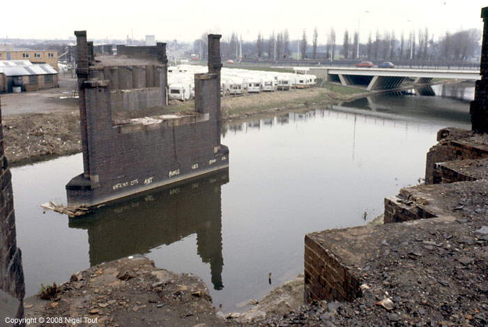
The site of the double span bridge across the River Soar, looking south west from Saint Margaret’s Way, with the centre support still in position in the middle of the river. The scene looked similar to this for over 20 years. |
|||
 |
|||
|
|
 |
|||||
|
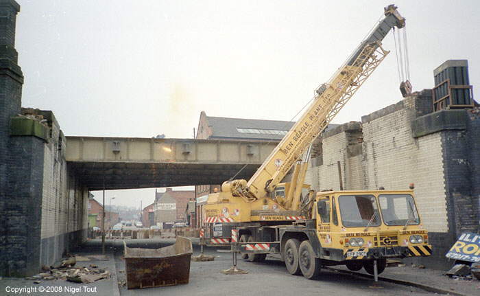
Oxy-acetylene cutting under way on the bridge over Slater Street, in the middle of the north viaduct. Looking west, 1982. |
|||||
 |
|||||
|
Panoramic view along Northgate Street shortly before demolition started in 1982. On the left is the bridge over the canal while on the right is the magnificent skew bridge leading into the Central Station which is out of sight. |
|||||
 |
|||||
|
The bridge over the Grand Union Canal in 1982, looking west. In the backgground is the brick bridge carrying Northgate Street across the canal. |
|||||
|
|
 |
||||||||||||||||||||||||||
|
The bridge over the canal from the west. |
||||||||||||||||||||||||||
 |
||||||||||||||||||||||||||
|
A few weeks later, immediately after the demolition of the length of viaduct shown below, the bridge over the canal was demolished. Looking east, 1982. |
||||||||||||||||||||||||||
 |
||||||||||||||||||||||||||
|
The sad sight of demolition of the viaduct between Northgate Street and the canal, in 1982. |
||||||||||||||||||||||||||
 |
||||||||||||||||||||||||||
|
During the demolition of the part of the north viaduct between Northgate Street and the canal in 1982 the preserved Great Central Railway was given the opportunity of rescuing anything of use before it was crushed. Volunteer workers are selecting some of the special bricks which would be especially useful in repairing bridges. |
||||||||||||||||||||||||||
 |
||||||||||||||||||||||||||
|
Looking south through Northgate Street bridge and over the cleared site of Leicester Central station using a telephoto lens, 1980. The lens has made the Pex building, alongside the Braunstone Gate viaduct, look much closer. |
||||||||||||||||||||||||||
 |
||||||||||||||||||||||||||
|
Some buildings were very close to the bridge and must have been very noisy when a train went over. |
||||||||||||||||||||||||||
 |
||||||||||||||||||||||||||
|
Northgate Street bridge, looking south towards Leicester Central Station,1980. |
||||||||||||||||||||||||||
 |
||||||||||||||||||||||||||
|
Northgate Street bridge after demolition has started, 1981 |
||||||||||||||||||||||||||
 |
||||||||||||||||||||||||||
|
The sad sight of Northgate Street bridge with demolition nearly complete, 1981 |
||||||||||||||||||||||||||
 |
||||||||||||||||||||||||||
|
The view looking along Northgate Street would never be the same without the railway bridge. Soon to follow would be the viaduct on the left and the Van Damme Bar, which was originally the Great Central Hotel. |
||||||||||||||||||||||||||
|
Around Leicester Central Station |
||||||||||||||||||||||||||
 |
||||||||||||||||||||||||||
|
The start of demolition of the bridge over Soar Lane, at the north end of Leicester Central Station, looking west, 1983. The Great Central Hotel, on the right, had become the Van Damme Bar, but was now closed and boarded up and was later demolished too. |
||||||||||||||||||||||||||
 |
||||||||||||||||||||||||||
|
Demolition of the bridge over Soar Lane is well advanced, looking west. |
||||||||||||||||||||||||||
 |
||||||||||||||||||||||||||
|
The final girder of the bridge across Soar Lane is brought down, looking east, 1983. |
||||||||||||||||||||||||||
 |
||||||||||||||||||||||||||
|
Looking south from the Leicester Central Station site with Welles Street in the foreground, 1980. To the left of centre is the abutment of the bridge over the river and to the left of it is the well known Pex building with the tower crane. |
||||||||||||||||||||||||||
|
West Bridge |
||||||||||||||||||||||||||
 |
||||||||||||||||||||||||||
|
Panoramic view of West bridge, just prior to demolition of all the bridges, looking away from the city centre, 1978. West Bridge Street is on the left, Saint
Augustine Street in the centre, and the river/canal on the right .A red contractor’s van is on the bridge over the river/canal. Leicester Central station is a couple of hundred yards to the right. |
||||||||||||||||||||||||||
 |
||||||||||||||||||||||||||
|
The final part of West Bridge Street bridge being removed, looking towards the city centre, 1978. The bridges and viaduct here were the first to be demolished so that improvements could be made to this busy road junction on the edge of the city centre. |
||||||||||||||||||||||||||
 |
||||||||||||||||||||||||||
|
Demolition of the viaduct alongside Dunns Lane. The bowstring bridge at Braunstone Gate can be send end-on above the viaduct still standing. |
||||||||||||||||||||||||||
|
Goods Shed |
||||||||||||||||||||||||||
 |
||||||||||||||||||||||||||
|
The goods shed during demolition in 1996. |
||||||||||||||||||||||||||
|
Upperton Road Viaduct |
||||||||||||||||||||||||||
 |
||||||||||||||||||||||||||
|
Upperton Road viaduct over the Great Central just south of the goods yard in 2007 just before demolition, looking east. By then it was in a poor state, with a leaning brick parapet and rusting ironwork, and had to have additional supports intalled underneath (see below). |
||||||||||||||||||||||||||
 |
||||||||||||||||||||||||||
|
Supports underneath a rusting section of Upperton Road viaduct, looking south. |
||||||||||||||||||||||||||
 |
||||||||||||||||||||||||||
|
In March 2007 the remaining track under Upperton Road viaduct was being cleared in preparation for the temporary diversionary road which was built for use while the viaduct was demolished. Compare with the photographs further down this page. |
||||||||||||||||||||||||||
 |
||||||||||||||||||||||||||
|
Looking south from the viaduct showing the track bed being cleared for the temporary road. In the distance the rails of the chord leading up to the ex-Midland Railway Leicester to Burton line can be made out. |
||||||||||||||||||||||||||
 |
||||||||||||||||||||||||||
|
Looking north from the viaduct, in March 2007. On the right are the remaining rails of the sidings and tracks that entered the goods yard while on the left is the Great Central Way footpath and cycle way on the track bed of the main line. |
||||||||||||||||||||||||||
 |
||||||||||||||||||||||||||
|
By August 2007 the wide bridge over the Old River Soar which lead into the goods yard had been demolished to make way for a Bailey bridge at a different angle. This carried the diverted traffic while the viaduct was demolished nd Upperton Road replaced. A girder of the old bridge lies in the foreground, on the left, and beyond it a temporary footbridge has already been installed. |
||||||||||||||||||||||||||
 |
||||||||||||||||||||||||||
|
For comparison, here is the same view as the previous photograph but in December 1973 when the coal yard and scrap yards were being shunted by 0-6-0 shunter number 3400. |
||||||||||||||||||||||||||
 |
||||||||||||||||||||||||||
|
This view in September 2007 shows the main Bailey bridge for the diverted road in place and just required finishing touches. |
||||||||||||||||||||||||||
 |
||||||||||||||||||||||||||
|
Looking from the west side of the viaduct in August 2007. Factories in the foreground had been demolished to make way for the temporary diversionary road and there was now a clear view of the viaduct that had not been possible for many years. |
||||||||||||||||||||||||||
 |
||||||||||||||||||||||||||
|
On 21st October 2007 demolition of the viaduct was under way and one steel span on the left had already been removed. |
||||||||||||||||||||||||||
 |
||||||||||||||||||||||||||
|
A little later cutting had progressed to the next steel span and demolition of the brick abutment on the left had started. |
||||||||||||||||||||||||||
 |
||||||||||||||||||||||||||
|
By 27th October 2007 all of the steel work of the viaduct had been removed and demolition of the brickwork at the western end of the viaduct was progressing rapidly. The powerful demolition equipment removed big chunks of the brickwork so the demolition was very quick. In the foreground are two of the mobile telescopic lighting towers with generators since demolition was authorised to continue through each night for the week. |
||||||||||||||||||||||||||
 |
||||||||||||||||||||||||||
|
By November 2007 the temporary road was open and the remains of the viaduct were slowly being removed. The pedestrian crossing is where the Great Central Way crosses the road. |
||||||||||||||||||||||||||
 |
||||||||||||||||||||||||||
|
The car has just crossed the Bailey bridge across the Old River Soar. This temporary bridge was being used while the remaining length of the viaduct over the river was demolished and replaced by a new permanent bridge. |
||||||||||||||||||||||||||
|
||||||||||||||||||||||||||
|
|
||||||||||||||||||||||||||
|
|


